Cassidy Lake
New Brunswick History
Europeans first settled in New Brunswick in 1611. These first settlers were French and the area was part of what the French called Acadia. The Acadians’ fortunes suffered after France was defeated at Quebec and ceded the territory to the English. In 1754 the English demanded an oath of allegiance. Many Acadians refused and in the subsequent years they were expelled and their lands confiscated.[1] Thus we have the start of English crown grants in New Brunswick .
The American Revolutionary War led to many English loyalists leaving the United States for Canada. Many came to Saint John in the period from 1781-1783 and were important in the development of the newly created Province of New Brunswick that had separated from Nova Scotia in 1784. Most inhabitants lived near waterways from which they derived their livelihood. The less accessible inland areas were just waiting to be tilled by energetic and resourceful people.
This was the milieu that William and Jane found when they landed in Saint John in 1819. Certainly they found more peaceful surroundings here than those in County Donegal which was fraught with frantic and constant political upheavals and sparse agricultural conditions. In all likelihood, their motivation to emigrate would have been primarily looking for an opportunity to escape English oppression. They would not have received any encouragement, grant, or financial support from the English crown. Given that there was probably little future for William and Jane in Ireland, Canada would appear as a land of opportunity.
[1] A good description of early New Brunswick history, in particular Kings County can be found in Dorothy Dearborn’s An Anecdotal History of Kings County New Brunswick.
Homestead Property
In 1825 William established a permanent homestead on 150 acres at DeForest Lake, 30 miles (48 km) from Saint John. The area was not totally virgin as Samuel DeForest had settled on the south side of the lake 28 years earlier in 1797. Brian Cassidy has traced the extent and ownership of the Cassidy property at Cassidy Lake through records in the New Brunswick Provincial Archives.
In May of 1815 we have the first survey of the Cassidy Lake area and transfer of property ownership to James DeCourcy by crown grant; a portion of which William Cassidy would eventually buy. In December of that same year, the DeCourcy property is sold to Elijah Baxter. Eight years later, in 1823, a 150 acre section of this land was purchased by William. The contract price for the property was £40 in New Brunswick currency, equivalent to about $5,000 in today’s dollars, payable in carpenter’s work over six years at an annual rate of £6 15s (6 pounds 15 shillings). William had the option to pay off the debt sooner by completing work that Elijah Baxter wanted done. The penalty for not living up to the terms of the contract was considerable, £150.
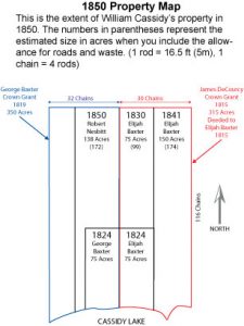
Through a series of transactions over 27 years, William expanded the property to its maximum of 596 acres in 1850 when if we include the 80 acres deeded to each of sons, William Jr. and James, in 1849. In 1849, William began divesting his holdings, passing the property on to various sons and other individuals. The largest section was deeded to son Francis Edward, who later passed it to his son Robert Allen, who in turn subdivided it and passed the portions on to his sons Stanley and Gordon. Gordon subdivided his portion and transferred it to sons Gordon and Douglas. Douglas sold his property about 2010. Gordon’s property went to his son, Tim, after Gordon died in 2010. Tim plans to sell it this property. The property Stan had went to his wife, Elsie, on his death. It was sold in 2012 to Paul Cassidy. This is what remains in the Cassidy name today and totals 193 acres.
Transaction Details
The 1850 Property Map shows the various parcels of land that William accumulated and disbursed. Transcripts of original documents make for interesting reading. They are available online in the downloads section.
May 8, 1815 – Samuel DeForest Crown Grant Samuel DeForest acquires property on south side of Cassidy Lake (1110 acres) by crown grant. This same grant allots adjacent properties to Nelson Nelson (300 acres), James Sederquest (300 acres) and William Sederquest (210 acres). The petition for this land was filed under the name James Sederquest on April 6, 1814. This crown grant is titled Samuel DeForest and 3 Others, Parish of Hampton, Kings County.
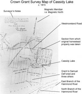
May 9, 1815 – James DeCourcy Crown Grant James DeCourcy acquires property on the north side of Cassidy Lake (315 acres) by crown grant. The 1815 survey map is from the original Crown Grant document. By the early 1800s the area around Cassidy Lake was well surveyed. The note in the upper left-hand corner by the Surveyor General, George Sproule, is important. It reads:
In the Calculation of the Four Lots, represented on this Plan, the usual allowance on Ten per Cent for roads and Waste has been deducted. Scale: 40 chains to one inch.
The DeCourcy property was rectangular in shape with an area of 315 acres and measured 116 chains to the lake on the west side and 120 rods wide. [1 rod = 16.5 feet (5 m), 1 chain = 4 rods, 1 acre (0.4 ha) = 160 sq. rods]. In today’s terminology the property was 7,656 feet (2,334 m) deep and 1980 feet (604 m) wide, or over a mile (0.68 km) deep and just under a half mile (0.3 km) wide.
Other notes of interest on the map are that the lake “Discharges into the North Branch of Hammond River.” The irregular section of property at the west end of the lake is “Reserved for Public Use.”
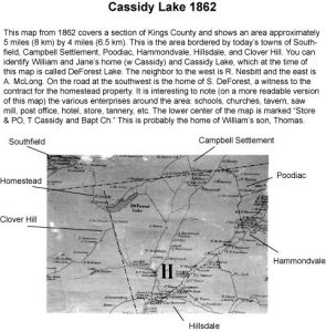
In this survey the lake is not named. From other sources, such as the 1862 map, we know that it was once called DeForest Lake, presumably after Samuel DeForest who owned the property along the south side of the lake. The naming of the lake is discussed later.
The same grant allots adjacent properties to Joseph Lee (220 acres), Archibald McLarren (1193 acres) and Thomas Orr (328 acres). The petition for this land, in the name of James DeCourcy, was signed on September 23, 1814 in Hampton, Kings County. This crown grant is titled Archibald McLarren and 3 Others, Parishes of Hampton and Sussex, Kings County.
December 23, 1815 – DeCourcy Property transferred to Elijah Baxter Only a few months after acquiring property on the north side of the lake, James DeCourcy sold it to Elijah Baxter. The deed gives a property size of 300 acres more or less. The actual size is likely closer to 315 acres as shown in the 1815 crown grant.
July 6, 1819 – George Baxter Crown Grant In 1819, George Baxter acquired a 350 acre lot immediately to the west of the original DeCourcy property. This property is significant because two sections of it were acquired by William Cassidy; one in 1824 (75 acres) and another in 1850 (138 acres).
January 3, 1823 – William Cassidy contracts to purchase a portion of the DeCourcy property from Elijah Baxter This is a purchase agreement for a portion of land (150 acres) owned by Elijah Baxter for £40. While it is likely that this land lies completely or primarily within the DeCourcy grant, its precise location, stated as 40 Rods on Elijah Baxter and 30 Rods on Land granted to George Baxter from thence to extend back to complete the amount of 150 Acres, is uncertain.
It appears that this contract was completed on June 9, 1824 with the formal property transfers from Elijah and George Baxter. Elijah Baxter must have been operating as an agent for George Baxter in this transaction. It’s interesting to note that while the contract price for the properties was £40, the deed shows a total of £58. Why the difference we do not know. A better understanding of the property transaction process at that time should provide some clarification.
The original copy of this agreement is currently in the possession of Brian Cassidy. It is currently unknown if copies of this agreement exist elsewhere or if it was ever registered with provincial authorities.
June 9, 1824 – William Cassidy purchases 75 acres from Elijah Baxter and 75 acres from George Baxter These were two independent transactions conducted on the same day. Both properties were identical in size (75 acres) and the sum of money transferred the same (£29). The Elijah Baxter property was taken from the southwest corner of the original 315 acre DeCourcy grant. The George Baxter property was taken from the southeast corner of that 350 acre property which he had acquired by crown grant in 1819. Each section consisted of 15 chains of lakefront property and was 50 chains deep.
September 3, 1830 – William Cassidy purchases 75 acres from Elijah Baxter This deed is for 75 acres located, as best we can determine, in the northwest section of the original DeCourcy property. It is interesting to note that this deed was not registered until February 27, 1841, the same date on which the next deed (dated January 6, 1841) between Elijah Baxter and William Cassidy was registered. According to crown grant survey maps, the true size of this lot was approximately 99 acres.
January 6, 1841 – William Cassidy purchases 150 acres from Elijah Baxter This transaction is for 150 acres located on the eastern side of the original DeCourcy property. With this deed, the Cassidy property had expanded to include all the land in the original DeCourcy property (315 acres) plus 75 acres of adjacent property to the west. According to crown grant survey maps, the true size of this lot was approximately 174 acres.
July 18, 1849 – William Cassidy transfers 80 acres to each of sons William Jr. and James A.
June 1, 1850 – William Cassidy purchases 138 acres from Robert Nesbitt This deed is for a strip of land on the western side of William’s property. This was land originally acquired in a crown grant of 350 acres by George Baxter in 1819, and 75 acres of which William purchased in 1824. The remaining 275 acres was purchased by Robert Nesbitt from Ralph Jarvis of Saint John in March of 1850. It has not been researched how this 275 acres was transferred from George Baxter to Ralph Jarvis. William purchased 138 acres from Robert Nesbitt which was one half of the property which Nesbitt had purchased from Jarvis. This deed is the first document in which the lake has a name and is referred to as Sidiques Lake. This purchase brought the total size of William’s property to its largest extent of 596 acres.
March 30, 1852 – William Cassidy sells 3 lots totaling 105 acres to the Kirkpatricks and Henry Cripps William Kirkpatrick, Sr. purchased 62½ acres for £20, and William Kirkpatrick, Jr. 32½ acres for £20. Henry Cripps purchased 10 acres for £5. We wonder if there is any connection between Henry Cripps and the circuit rider James Cripps who encouraged Francis Edward Cassidy to build the church in 1882.
July 1, 1867 – Confederation of Canada New Brunswick, Nova Scotia, Quebec and Ontario become Canadian provinces. At this time the currency of New Brunswick changed from pounds (£) to dollars ($).
September 24, 1868 – William Cassidy transfers 250 acres to son Francis Edward This deed transfers ownership of a section of William’s property to Francis Edward Cassidy totaling 250 acres. In this agreement, the lake is named DeForest Lake. The deed says the fee paid was $2,000 implying it was not a gift from William to his son Francis Edward. Because this transaction was some 18 years before William died, our speculation is that this transaction was essentially an agreement for Francis Edward to take care of William in his later years.
February 24, 1872 – William Cassidy sells 80 acres to William Kirkpatrick The price paid for this land was $240.
September 16, 1875 – Francis Edward Cassidy acquires 80 acres by way of mortgage from William Kirkpatrick In this transaction, Francis Edward buys back the 80 acres sold to William Kirkpatrick by William three years earlier.
1883 – Cassidy Lake Church constructed.
March 26, 1886 – William Cassidy dies at age 89
June 3, 1890 – Francis Edward Cassidy transfers church property to the Methodist Church The property described in this agreement was transferred to the Methodist church on June 3, 1890. Included in this agreement are the cemetery and an access road between the church and the cemetery. A copy of this agreement is in the possession of Brian Cassidy. This property is New Brunswick land PID 152413. 13
c1920 – Francis Edward Cassidy transfers property to son Robert Allen
October 25, 1927 – Francis Edward Cassidy dies at age 93
1952 – Robert Allen Cassidy transfers part of property to son Leslie Gordon This area was 125 acres or approximately 40 per cent of the total Cassidy property.
1954 – Leslie Gordon Cassidy transfers part of his property to son Gordon This is New Brunswick land PID 00100016 (10 acres).
1954 – Leslie Gordon Cassidy transfers part of his property to son Douglas This is New Brunswick land PID 00100008 (115 acres)
1954 – Robert Allen Cassidy transfers property to son Stanley Bernard This is New Brunswick land PID 200766 (193 acres) and is essentially the same as the original property purchased by William Cassidy from Elijah Baxter January 3, 1823.
May 8, 1965 – Robert Allen Cassidy dies at age 86
May 6, 1993 – Stanley Bernard Cassidy dies at age 81 leaving the property to wife Elsie The will of Stanley Cassidy left his portion of the Cassidy Lake property to son Peter. However, ownership transferred to Stan’s wife, Elsie, as she was joint tenant on the deed. This is New Brunswick PID 200766 (193 acres).
July 23, 2012 – Paul Cassidy purchases the property from Elsie Cassidy. Paul’s objective was simply to keep the property in the Cassidy family. Paul is a great-great-grandson of Francis Edward Cassidy. A survey of the property put it at approximately 150 acres.
2019 – Paul Cassidy opens Camp Cassidy as a wellness center and outdoor recreation facility for veterans of the Canadian Armed Services. Camp Cassidy utilizes the homestead property as well as the church. Access to the property and cemetery is by prior permission. More on Camp Cassidy.
Name of the Lake
In the crown grants of 1815, the lake is unnamed. In the deeds of 1850, it is called Sidiques Lake. No doubt this has to do with the crown grants to James and William Sederquest. A New Brunswick map of 1862 shows the name as DeForest Lake as does the deed of September 24, 1868. The name was changed to Cassidy Lake after this date, likely between 1870 and 1889. The first known reference to the name Cassidy Lake is the 1890 church property transfer agreement. However, we still find it being referred to as DeForest Lake as late as 1940. The search continues for information which formalizes these name changes.
Spelling of Names
Official New Brunswick Provincial Archive records show the name on the crown grant and petition as James DeCourey. The deed which transferred the property to Elijah Baxter is officially registered under the spelling DeCourcey. An inspection of the actual grant and petition (microfilm) showing James’ own signature is inconclusive. James was of Irish ancestry and both spellings are in use although DeCourey appears to be the more common. An inspection of the actual deed (microfilm) text and James signature appears to show DeCoursey.
We have a similar problem with another spelling: Sederquist, Sederquest, Sidiques.
Locating Cassidy Lake
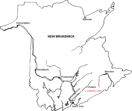
Cassidy Lake and the site of the family homestead are located in southern New Brunswick. They are 30 miles (50 km) from Saint John, 50 miles (80 km) from Moncton and 80 miles (130 km) from the provincial capital Fredericton. On a finer scale, they are 9 miles (14 km) from the town of Norton and 15 miles (24 km) from Sussex, both of which are the nearest major population centers.
The way to the lake is over county roads. The most common route is from Highway 1 at Sussex via County Road 111. The Sussex road, until the Norton road was paved in 2001, was generally in better condition, especially in the springtime. The homestead site is on the north side of the lake, facing south and directly overlooking the church. The church is located on the narrow strip of land between the county road and the lake.
GPS Coordinates
Church: N 45 34.958 / W 65 35.002
Cemetery: N 45 35.126 / W 65 35.112